
I’ve suffered from a bit of the blues in this new year, so two weekends ago I logged into Steam and bought a new game to relax a little. It’s been a few years since I’ve bought a new game, and in playing this one and perusing my existing collection I realized they all had one thing in common: geography plays a central role in all of them. So in this first post of the year, I’ll explore the role of geography in video games using examples from my favorites.
Terrain and Exploration in 4X Games
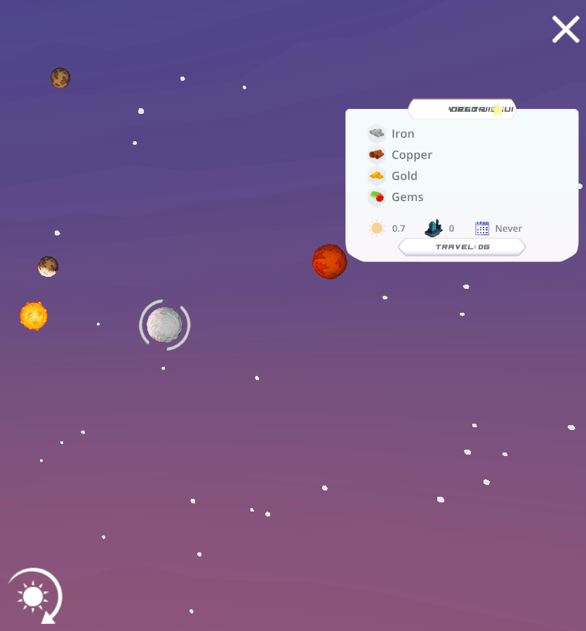
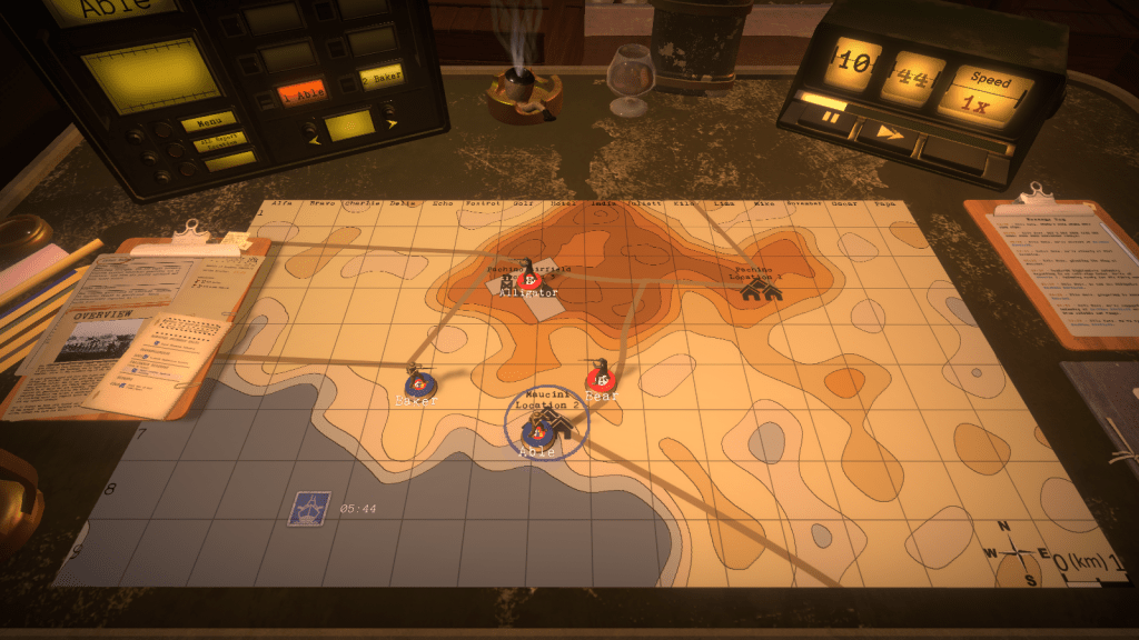
My latest purchase is Signals by MKDB Studios, an indie husband and wife developer team in the UK. It can be classified as a “casual” game, in that it’s: easy to learn and play yet possesses subtle complexity, is relatively relaxing in that it doesn’t require constant action and mental exertion, and you can finish a scenario or round in an hour or so. In Signals, you are part of a team that has discovered an alien signaling device on a planet. The device isn’t working; fixing it requires setting up a fully functional research station adjacent to the device, so you can unlock its secrets. The researchers need access to certain key elements that you must discover and mine. The planet you’re on doesn’t have these resources, so you’ll need to explore neighboring systems in the sector and beyond to find and bring them back.
Space travel is expensive, and the further you journey the more credits (money) you’ll need. To fund travel to neighboring systems in search of the research components (lithium, silicon, and titanium) you can harvest and sell a variety of other resources including copper, iron, aluminum, salt, gold, gems, diamonds, oil, and plutonium. As you flood the market with resources their value declines, yielding diminishing returns. You must be strategic in hopping from planet to planet and deciding what to harvest and sell. Mining resources incurs initial fixed costs for building harvesters (one per resource patch), a solar array for powering them (which can only cover a small area), and a trade post for moving resources to the market (one per planet).

The game has two distinct views: one displays the terrain of the planet you’re on, while the other is a map of the sector(s) with different solar systems, so you can explore the planets and their resources and make travel plans. Different terrain provides different resources and imposes limits on game play. You are precluded from constructing buildings on water and mountains, and must clear forests if you wish to build on forested spaces. Terrain varies by type of planet: habitable Earth-like, red Mars-like, ice worlds, and desert worlds. The type of world influences what you will find in terms of resources; salt is only found on habitable worlds, while iron is present in higher quantities on Mars-like worlds. Video games, like maps, are abstractions of reality. The planet view shows you just a small slice of terrain that stands in for the entire world, so that the game can emphasize the planet hopping concept that’s central to its design. The other view – the sector map – is used for navigation and reference, keeping track of where you are, where you’ve been, and where you should go next.

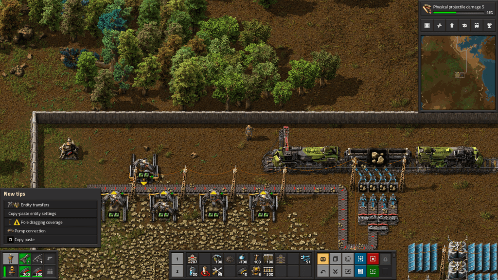
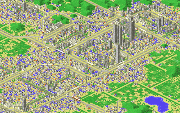
The use of terrain and the role of physical geography are key aspects in simulators (like SimCity, an old favorite) and the so-called 4X games which focus on exploration, mining, trading, and fighting, although not all games employ all four aspects (Signals has no fighting or conquest component). Another example of a 4X game is Factorio by Wube Software, which I’ve written about previously. Like Signals, exploring terrain and mining resources are central to the game play. Similarities end there, as Factorio is anything but a casual game. It requires a significant amount of research and experimentation to learn how to play, which means consulting wikis, tutorials, and YouTube. It also takes a long time – 30 to 40 hours to complete one game!
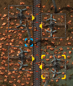
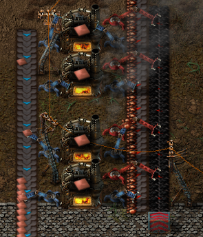
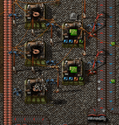
The action in Factorio occurs on a single planet, where you’re looking for resources to mine to build higher order goods in factories, that you turn into even higher order products as you unlock more technologies by conducting research, with the ultimate goal of constructing a rocket to get off the planet. There are also two map views: the primary terrain view that you navigate as the player, and an overview map displaying the extent of the planet that you’ve explored. You begin with good knowledge of what lies around you, as you captured this info before your spaceship crashed and marooned you here. Beyond that is simply unknown darkness. To reveal it, you physically have to go out and explore, or build radar devices that gradually expand your knowledge. The terrain imposes limits on building and movement; water can’t be traversed or built upon, canyons block your path, and forests slow movement and prevent construction unless you chop them down (or build elsewhere). The world generated in Factorio is endless, and as you use up resources you have to push outward to find more; you can build vehicles to travel more quickly, while conveyor belts and trains can transport resources and products to and around your factory; this growing logistical puzzle forms a large basis of the game.
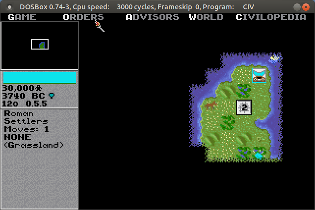
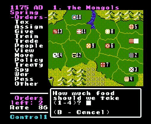
The role of terrain and exploration has long been a mainstay in these kinds of games. Thanks to DOSbox (an emulator that let’s you run DOS and DOS programs on any OS), I was recently playing the original Sid Meier’s Civilization from 1991 by Microprose. This game served as a model for many that followed. Your small band of settlers sets out in 4000 BC, to found the first city for your particular civilization. You can see the terrain immediately around you, but the rest of the world is shrouded in darkness. Moving about slowly reveals more of the world, and as you meet other civs you can exchange maps to expand your knowledge. The terrain – river basins, grasslands, deserts, hills, mountains, and tundra – influences how your cities will grow and develop based on the varying amount of food and resources it produces. Terrain also influences movement; it is tougher and takes longer to move over mountains versus plains, and if you construct roads that will increase speed and trade. The terrain also influences attack and defense capabilities for military units…
Terrain and Exploration in Strategic Wargames
Strategic war games are another genre where physical geography matters. One weekend shortly after the pandemic lock-down began in 2020, I dug my old Nintendo out of the closet and replayed some of my old favorites. Desert Commander by Kemco was a particular favorite, and one of Nintendo’s only war strategy games. You command one of two opposing armies in the North African desert during World War II, and your objective is simple: eliminate the enemy’s headquarters unit, or their entire army. You have a mix of tanks, infantry, armored cars, artillery, anti-aircraft guns, supply trucks, fighters, and bombers at your command. Each unit varies in terms of range of movement and offensive and defensive strength, in total and relative to other units. Tanks are powerful attackers, but weak defenders against artillery and hopeless against bombers. Armored cars cruise quickly across the sands compared to slowly trudging infantry.
Terrain also influences movement, offense, and defense. You can speed along a road, but if you’re attacked by planes or enemy tanks you’ll be a sitting duck. Desert, grassland, wilds (mountains), and ocean make up the rest of the terrain, but scattered about are individual features like pillboxes and oases which provide extra defense. A novel aspect of the game was its reliance on supply: units run low on fuel and ammo, and after combat their numbers are depleted. You can supply fuel and ammo to ground units with trucks, but eventually these also run out of gas. Scattered about the map are towns, which are used for resupply and reinforcement. There are a few airfields scattered about, which perform the same functions for aircraft. Far from being a simple battle game, you have to constantly gauge your distance and access to these supply bases, and consider the terrain that you’re fighting on. The later scenarios leave you hopelessly outnumbered against the enemy, which makes the only winning strategy a defensive one where you position your headquarters and the bulk of your forces at the best strong point, while simultaneously sending out a smaller strike force to get the enemy HQ.
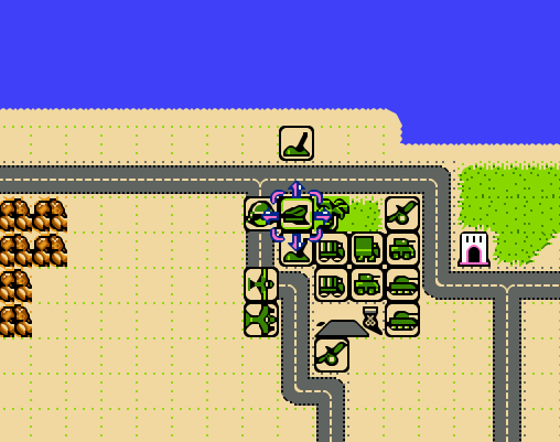
There have been countless iterations and updates on this type of game. One that I have in my Steam library is Unity of Command by 2×2 Games, which pits the German and Soviet armies in the campaigns around Stalingrad during World War II. Like most modern turn-based games, the grid structure (used in Desert Commander) has been replaced with a hex structure, reflecting greater adjacency between areas. Again, there are a mix of different units with different strengths and capabilities. The landscape on the Russian steppe is flat, so much of the terrain challenge lies in securing bridgeheads or flanking rivers when possible, as attacking across them is suicidal. The primary goal is to capture key objectives like towns and bridgeheads in a given period of turns. A unit’s attack and movement phase are not strictly separated, so you can attack with a unit, move out of the way, and move another in to attack again until you defeat a given enemy. This opens up a hole, allowing you to pour more units through a gap to capture territory and move towards the objectives. The supply concept is even more crucial in UOC; as units move beyond their base, which radiates from either a single point or from a roadway, they will eventually run out of supplies and will be unable to fight. By pushing through gaps in defense and outflanking the enemy, you can capture terrain that cuts off this supply, which is more effective than trying to attack and destroy everything.

The most novel take on this type of game that I’ve seen is Radio General by Foolish Mortals. This WWII game is a mix of strategy and history lesson, as you command and learn about the Canadian army’s role in the war (it incorporates an extensive amount of real archival footage). As the general commanding the army, you can’t see the terrain, or even where any of the units are – including your own. You’re sitting behind the lines in a tent, looking at a topographic map and communicating with your army – by voice! – on the radio. You check in and confirm where they are, so you can issue orders (“Charlie company go to grid cell Echo 8”), and then slide their little unit icons on the map to their last reported position. They radio in updates, including the position of enemy units. The map doesn’t give you complete and absolute knowledge in this game; instead it’s a tool that you use to record and understand what’s going on. Another welcome addition is the importance of elevation, which aids or detracts in movement, attack, defense, and observation. A unit sitting on top of a hill can relay more information to you about battlefield circumstances compared to one hunkered down in a valley.
Strategy Games with the Map as Focal Point
While terrain takes center stage in many games, in others all the action takes place on a map. Think of board games like Risk, where the map is the board and players capture set geographic areas like countries, which may be grouped into hierarchies (like continents) that yield more resources. Unlike the terrain-based games where the world is randomly generated, most map-based games are relatively fixed. Back to the Nintendo, the company Koei was a forerunner of historical strategy games on consoles, my favorite being Genghis Khan. The basic game view was the map, which displayed the “countries” of the world in the late 12th and early 13th centuries. Each country produced specialized resources based on its location, had military units unique to its culture, and produced gold, food, and resources based on its infrastructure. Your goal was to unite Mongolia and then conquer the world (of course). Once you captured other countries, they remained as distinct areas within your empire, and you would appoint governors to manage them. When invading, the view switched from an administrative map mode to a battlefield terrain mode, similar to ones discussed previously.
Fast forward to now, and Paradox has become a leading developer of historical strategy games. Crusader Kings 2 is one of their titles that I have, where the goal is to rule a dynasty from the beginning to the end of the medieval period in the old world. Conquering the entire world is unlikely; you aim to rule some portion of it, with the intention of earning power and prestige for your dynasty through a variety of means, warlike and peaceful. These are complex games, which require diving into wikis and videos to understand all the medieval mechanics that you need to keep the dynasty going. Should you use gavelkind, primogeniture, seniority, or feudal elective succession? Choose wisely, otherwise your kingdom could fracture into pieces upon your demise, or worse your nefarious uncle could take the throne.
CK2 takes human geographical complexity to a new level with its intricate hierarchy of places. The fundamental administrative unit on the map is a county. Within the county you have sub-divisions, which in GIS-speak are like “points in polygons”: towns ruled by a non-noble mayor, parishes ruled by a bishop, and maybe a barony ruled by a noble baron. Ostensibly, these would be vassals to the count, while the count in turn is a vassal to a duke. Several counties form a duchy, which in turn make up a kingdom, and in some cases several kingdoms are part of empires (i.e. Holy Roman and Byzantine). In every instance, rulers at the top of the chain will hold titles to smaller areas. A king holds a title to the kingdom, plus one or more duchies, one or more counties (the king’s demesne), and maybe a barony or two. If he / she doesn’t hold these titles directly, they are granted to a vassal. A big part of the game is thwarting the power of vassals to lay claim to your titles, or if you are a vassal, getting claims to become the rightful heir. Tracking and shaping family relations and how they are tied to places is a key to success, more so than simply invading places.
Which in CK2, is hard to do. Unlike other war games, you can’t invade whoever you want (unless they are members of a rival religion). The only way to go to war is if you have a legitimate claim to territory. You gain claims through marriage and inheritance, through your vassals and their claims, by fabricating claims, or by claiming an area that’s a dejure part of your territory, i.e. that is historically and culturally part of your lands. While the boundaries of the geographic units remain stable, their claims and dejure status change over time depending on how long they’re held, which makes for a map that’s dynamic. In another break from the norm, the map in CK2 performs all functions; it’s the main screen for game play, both administration and combat. You can modify the map to show terrain, political boundaries, and a variety of other themes.
Conclusion
I hope you enjoyed this little tour, which merely scratches the surface of the relation between geography and video games, based on a small selection of games I’ve played and enjoyed over the years. There’s a tight relationship between terrain and exploration, and how topography influences resource availability and development, the construction of buildings, movement, offense and defense. In some cases maps provide the larger context for tracking and explaining what happens at the terrain level, as well as navigating between different terrain spaces. In other cases the map is the central game space, and the terrain element is peripheral. Different strategies have been employed for equating the players knowledge with the map; the player can be all knowing and see the entire layout, or they must explore to reveal what lies beyond their immediate surroundings.
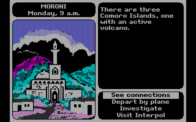
There are also a host of geographically-themed games that make little use of maps or terrain. For example, Mini Metro by Dinosaur Polo Club is a puzzle game where you connect constantly emerging stations to form train lines to move passengers, using a schematic resembling the London tube map. In this game, the connectivity between nodes in a network is what’s important, and you essentially create the map as you go. Or 3909 LLC’s Papers, Please, a dystopian 1980s “document simulator” where you are a border control guard in an authoritarian country in a time of revolution, checking the documentation of travelers against ever changing rules and regulations (do traveler’s from Kolechia need a work permit? Is Skal a city in Orbistan or is this passport a forgery…). Of course, we can’t end this discussion without mentioning Where in the World is Carmen Sandiego, Broderbund’s 1985 travel mystery that introduced geography and video games to many Gen Xers like myself. Without it, I may have never learned that perfume is the chief export of Comoros, or that Peru is slightly smaller than Alaska!


You must be logged in to post a comment.